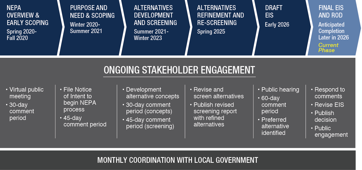
Study Overview
Project Update
Current as of: 7/27/2026
As a result of evaluating potential design shifts, additional funding was requested, and granted, to conduct the necessary technical work, including supplemental field surveys for wetlands and cultural resources, updated traffic analysis and engineering design for the revised alternatives, and the finalization of the impact analysis required to thoroughly respond to all public and stakeholder comments. The updated schedule will be shared once finalized.
Watch Draft EIS Summary Video
Heber Valley Corridor Draft Environmental Impact Statement (EIS) Virtual Meeting and Q&A: Jan. 27, 2026
- Virtual Meeting Guide 8:52
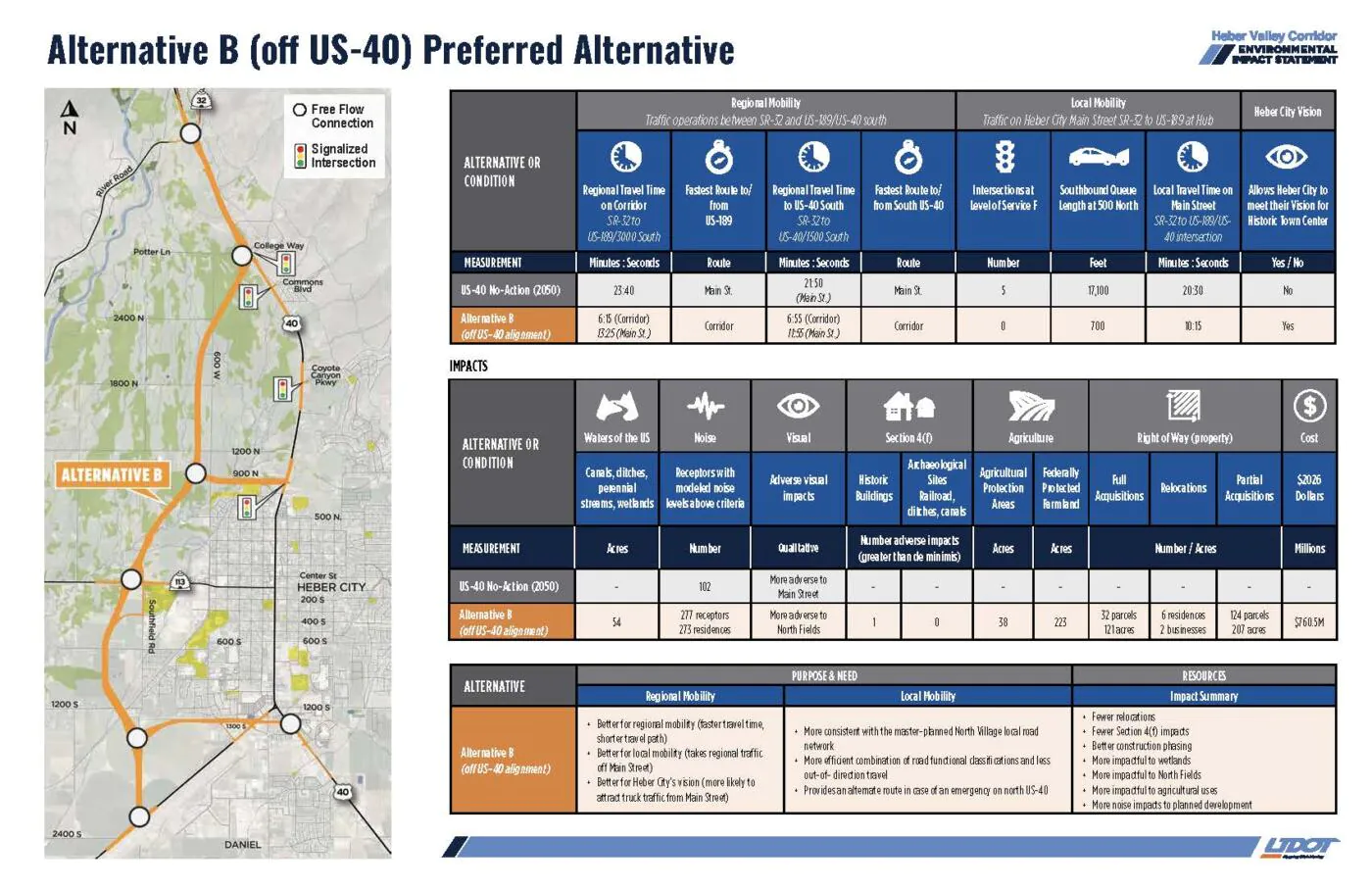
- Display Boards 12:20 to 38:12
- Contact Information 1:49:47
- Draft EIS Information 9:56
- Draft EIS Summary Video 10:15
- Alternative A Fact Sheet 17:09
- Alternative B Fact Sheet 18:55
- Noise Walls 34:53
- Noise Technical Report 35:20
- Draft EIS Executive Summary 20:33
- Draft EIS Environmental Analysis & Mitigation 24:40
Draft EIS Alternatives Map
Current Phase
Project Update
Completed Activities
Public Outreach
- Met with North Fields Irrigation Company to discuss potential impacts to historic ditches
- Responded to stakeholder inquiries
Ongoing Activities
Reviewing Formal Public Comments
We are continuing to review all comments received during the formal public comment period and are developing responses, which will be published in the Final EIS. All comments, regardless if they were submitted during the formal comment period, are reviewed by the team.
Responses to the most common questions from the comment period were published in the spring and are available in the FAQ section of the project website.
Addressing Public Comments
In response to the comments received, we are evaluating the traffic operations and potential resource impacts of suggested design refinements to the alternatives. These potential design refinements include:
- Shifting 1300 South further south
- Shifting Alternative B through the North Fields further east
- Including bicycle and pedestrian crossings through the SR-113 Single-Point Urban Interchange (SPUI)
As a result of evaluating potential design shifts, additional funding was requested and granted by the Utah Transportation Commission to conduct the necessary technical work.This includes supplemental field surveys for wetlands and cultural resources, updated traffic analysis and engineering design for the revised alternatives, and the finalization of the impact analysis required to thoroughly respond to all public and stakeholder comments.
Once the additional surveys, traffic analyses, and design refinements are completed, the same screening criteria and methodology used earlier in the study will be used to evaluate the shift options to determine which design refinements will be incorporated into the alternatives in the Final EIS.
What to expect next
Final EIS Publication
The Final EIS and Record of Decision (ROD), anticipated to be published jointly as the final step in the EIS process, are expected to be delayed due to the additional analyses and evaluation of potential design refinements. An updated schedule will be shared once finalized.
Implementation of the selected alternative may only occur after the ROD is issued; other permits and authorizations are obtained; and when federal, state and/or private funding is identified. At this time, no funding for implementing a selected alternative has been identified.
To view the Draft EIS, please visit https://hebervalleyeis.udot.utah.gov/draft-eis/
Study Process & Timeline
The anticipated project timeline outlines the phases to accomplish development of the Heber Valley Corridor EIS. Ongoing engagement with the public will take place during the estimated time periods to keep the community informed during the EIS.