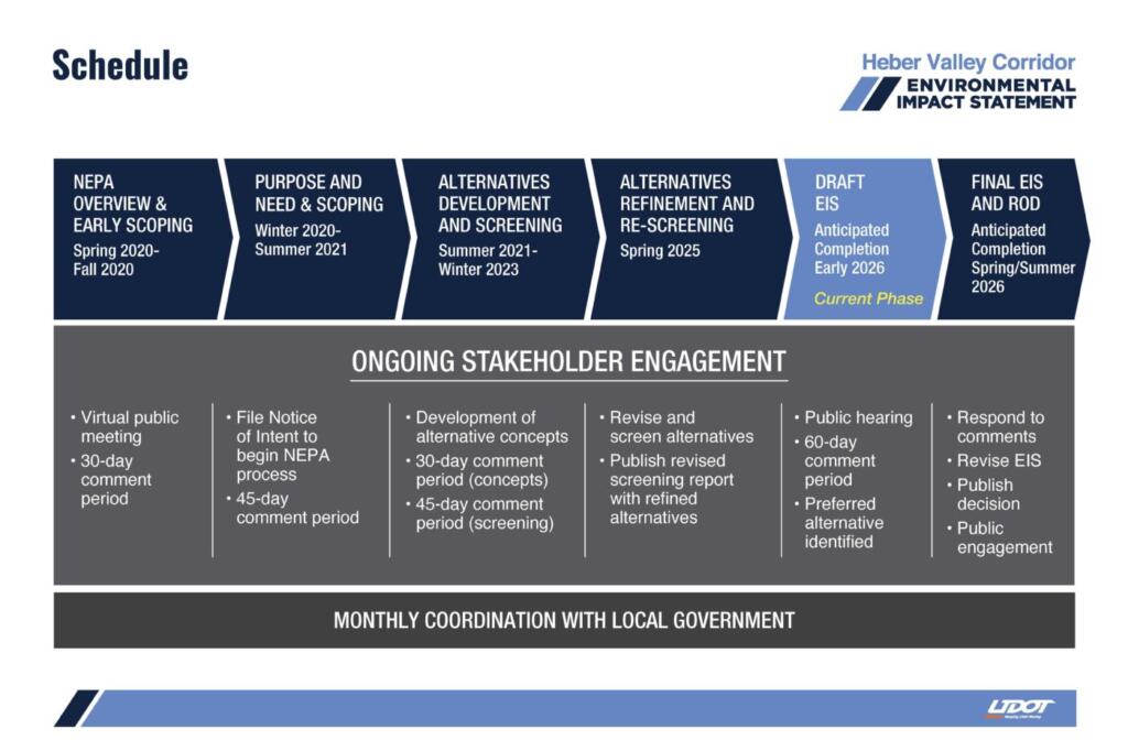
DRAFT EIS
The Draft EIS was published on Jan. 7, 2026. This document details what alternatives were considered, and the associated potential environmental effects and mitigation from the alternatives, and reasons for identifying the preferred alternative, Alternative B.
Draft EIS Frequently Asked Questions
PREFERRED ALTERNATIVE
Why is Alternative B considered to be the "best option for the community?"
- Reduces Main Street congestion by providing a faster, more direct route for cars and heavy trucks. It reduces regional traffic in the historic town center, making it safer and more pedestrian-friendly.
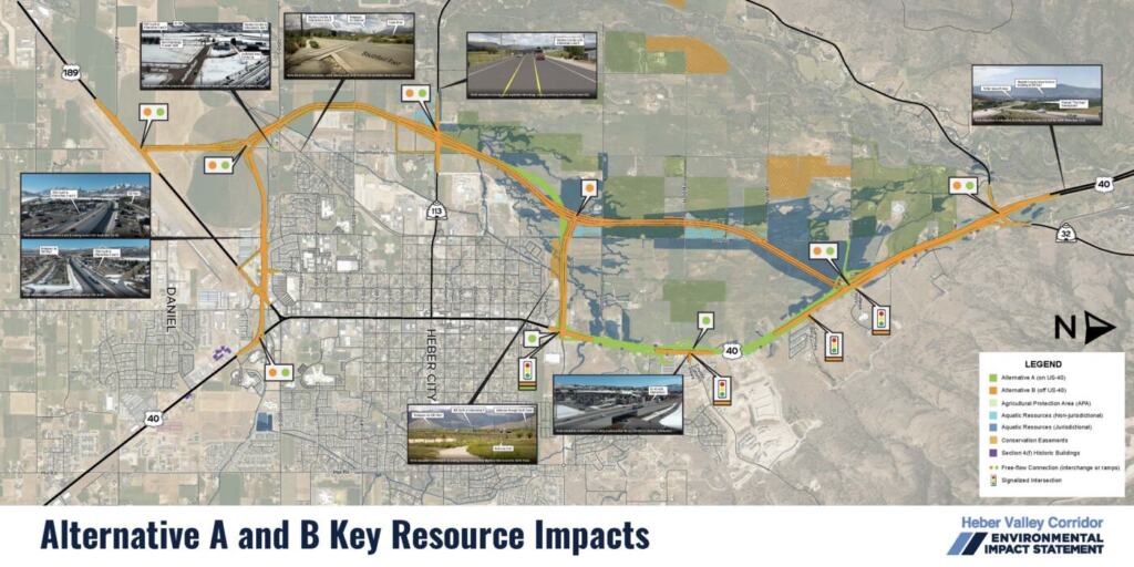
- Alternative B minimizes property disruption, requiring significantly fewer relocations, affecting only 8 properties (2 businesses and 6 homes) compared to 27 under Alternative A.
- Improves safety and reliability by separating local traffic from regional travelers and provides a critical alternative route through the valley in case of emergencies or road closures.
- Supports long-term growth through design that offers more room for future traffic needs.
- No-access: While it impacts some agricultural land, UDOT is committing to strict “no-access” rules to prevent new development and to permanent protection of sections of the North Fields as wetland mitigation.
Is saving one minute in travel time for Alternative B really worth the impacts to the North Fields?
- Reduces Main Street congestion because it is the faster and more direct route, navigation apps like Google Maps will often steer heavy trucks and through-traffic away from downtown, preventing gridlock at major intersections.
- While a minute or two per trip seems small, it adds up to a collective 250,000 hours saved per year for the community compared to Alternative A.
- Alternative B is much less disruptive to neighbors, requiring only 8 total relocations (2 businesses and 6 homes), whereas Alternative A would displace 27.
- Protects Historic Downtown with fewer impacts to historic buildings and helps turn North US-40 into a quieter local road, making the town center safer and more accessible for residents.
- It provides reliable emergency and school access by creating a second way out of the valley during emergencies and offers a more efficient commute for students traveling to the new high school.
Why didn’t you use the corridor that Heber City and Wasatch County have been preserving since 2006/2007 (local government preservation corridor)?
- Space Limitations: While both alternatives follow local government preservation corridors where possible (such as 900 North and 1300 South), the existing 84-foot-wide path is too narrow for the 250 feet required for these designs.
- Safety and Mobility: Narrower, slower-speed road designs were considered but eliminated early because they failed to meet the project’s core goals for regional and local mobility.
- Avoiding Impacts: UDOT shifted the path off the preserved corridor in several areas to avoid key sites, including local wetlands, the new high school, and residential developments like Kimball Villas. The alignment was moved south of the “hub” intersection to avoid impacting existing businesses.
- Engineering Requirements: The high design speeds require wide, gradual curves rather than sharp turns, and UDOT must balance the impacts on all environmental and community resources rather than prioritizing just one.
Is the primary justification for the plan the ability to enable commercial truckers to bypass Main Street? Who does this project benefit?
- The purpose of the project is to improve regional and local mobility and provide opportunities for non-motorized transportation while allowing Heber City to meet their vision for the historic town center.
- The purpose is not focused specifically on removing commercial truck traffic from Main Street to improve mobility, it is focused on reducing traffic in general, which includes commercial trucks.
- Removing commercial truck traffic would help Heber City meet their vision for the historic town center to become a destination for business to grow and for placemaking to foster a pleasant street atmosphere.
- In 2050, traffic on Main Street is projected to be 50% local, 25% regional (commuters and visitors), and 25% through traffic with the No-action Alternative. The project would benefit all travelers by relieving congestion on Main Street and offering alternate routes.
- With Alternative B, there would be more local traffic and less through traffic on Main Street in 2050: 53% local traffic, 33% regional, and 14% through traffic.
- The Heber Valley Corridor would serve all types of traffic. North of SR-113 (100 S), the split would be 18% local, 43% regional (commuters and visitors), and 39% through. South of SR-113, the split would be 26% local, 28% regional, and 46% through traffic.
Why doesn’t the preferred alternative include a direct connection (ramps) between College Way and the Heber Valley Corridor?
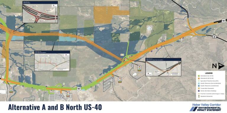
- The preferred alternative includes a traffic signal at the intersection of US-40 and College Way. Travelers wanting to access the Heber Valley Corridor from College Way would travel on north US-40 to 900 North, where a connection would be available.
- Our traffic analysis shows that the planned traffic signals on north US-40 function at an acceptable level of service without ramps. The benefit of constructing ramps would not outweigh the additional expense and impacts to construct them.
TRAIL
People won’t use the trail crossing the new corridor at Midway Lane because of the out of direction travel, can you provide a more direct route?
- The proposed trail would require out of direction travel, but meets safety design standards. It offers a safe way across the corridor without pedestrians or cyclists having to cross traffic, so they would not have to stop and wait at crossing points.
- A bike lane or sidewalk along the shoulder of SR-113 (100 S) could be incorporated into the design–those trail users would have to stop and wait at signals for a safe time to cross.
- We have received comments on the Draft EIS suggesting other solutions, we are in the process of evaluating them.
Who would maintain the trail?
- UDOT has historically required local governments to maintain trails.
- It is undecided if a trail constructed with this project would be part of the Utah Trail Network (UTN). Being part of the UTN does not guarantee UDOT would maintain the trail.
TRAFFIC
Will it reduce cut-through traffic on River Road, Mill Road, or 3000 South?
- We expect traffic on River Road to decrease with Alternative B because the western corridor provides a higher speed alternative.
- We expect traffic on Mill Road to decrease because the congestion on Main Street would be reduced in a way that would attract traffic away from Mill Road.
- We don’t expect a change on 3000 South. It is not well suited for larger freight vehicles or recreational vehicles. Alternative A and B would reduce congestion at the hub intersection, incentivizing regional traffic to remain on state highways.
Why are more signals being added to (e.g., 900 N or Potter Ln/College Way) to manage through traffic on US-40? Won’t that make traffic worse?
- Increasing development generates more traffic, which requires additional signals to manage turning movements and maintain safety.
- New signals on North US-40 are necessary for safety but they reduce travel efficiency, highlighting the need for a long-term corridor solution.
- New signals at 900 North and Coyote Canyon Parkway were installed only after a formal evaluation indicated they were necessary for better traffic flow and safety.
- UDOT is separately studying the installation of median barriers on North US-40 to improve safety now, rather than waiting for the larger corridor construction.
- When barriers are installed, new signals at Commons Boulevard and University Avenue will be added to provide safe locations for vehicles to make U-turns.
RIGHT OF WAY
Can UDOT condemn property that is in agricultural protection?
- Yes. UDOT is a state agency, not a political subdivision (such as a county, city, town, or special service district). Eminent domain restrictions for condemning land within an APA (Agricultural Protection Area) do not apply to UDOT or other state agencies.
- However, UDOT prefers to work with landowners to negotiate an agreement and avoid condemnation.
Will people be compensated for indirect impacts like increased noise, increased traffic, or visual impacts?
- UDOT provides compensation at fair market value when there are direct impacts – such as when all or part of a property is needed for a project.
- However, UDOT does not compensate for indirect impacts when no property is needed. State law does not allow compensation for indirect impacts when there is not a direct impact.
NORTH FIELDS / WETLANDS
How will the project preserve the valley's rural character, majesty, peace, wildlife, and essence, given the concern about "desecrating the North Fields?" Will this project result in development of the north fields?
- UDOT will prioritize the North Fields for wetland mitigation, protecting these areas from development in perpetuity.
- To prevent unwanted development, UDOT commits to no new access points on the corridor through the North Fields between Potter Lane and SR-113.
- For every acre impacted, UDOT may mitigate between 2 and 15 acres, ensuring the community gains more protected land than is lost.
- Mitigated lands will be removed from private ownership, limiting the potential for future development.
- Final mitigation plans are developed at the time of permitting, when the study is complete and the project moves into final design. During final design, the alignment developed during the EIS will be further refined. UDOT will work with willing sellers to identify areas for mitigation and will work with USACE to develop a detailed mitigation plan.
Alternative A has fewer impacts to the wetlands in the North Fields, would UDOT even get a permit to construct Alternative B?
- Balancing Different Impacts: While Alternative A affects fewer wetlands and water sources, federal guidelines require UDOT to consider all types of environmental and community damage, not just water-related impacts.
- Protecting Homes and Businesses: Alternative B is significantly less disruptive to the local community, requiring only 8 relocations of homes or businesses compared to 27 required by Alternative A.
- Preserving Historic Buildings: UDOT determined that Alternative B causes the “least overall harm” to historic properties, which are protected by strict federal preservation laws.
- Least Overall Harm: Because it saves more homes, businesses, and historic sites, UDOT believes Alternative B is the most practicable and least damaging choice overall in accordance with Section 404(b)(1) guidelines, though final federal approval on water impacts is still pending.
1300 SOUTH
Is the extension of 1300 S necessary?
- The 1300 South segment is a critical connection for both local and regional traffic for Alternative A and B. Without an east-west connection, the western corridor would not divert enough traffic from Main Street to fulfill the project’s purpose of improving mobility and reducing congestion. 1300 South provides an important route for traffic from the west side of the Heber Valley to access the commercial centers on the south end of Heber City and for traffic from south US-40 to access the western corridor.
- In 2006–2007, Wasatch County and Heber City identified an east-west connection on 1300 South for corridor preservation. This corridor has been represented on adopted transportation plans since then.
Can you shift the east-west connection south of 1300 South?
- We put the east-west connection on 1300 South because that is where it is identified in approved planning documents and our travel demand model shows 1300 South functions well as an east-west connection.
- The area between Southfield Road and south US-40 is very constrained with existing development and the airport. The project team has worked to reduce impacts along the 1300 South corridor as much as possible, balancing transportation needs with community and environmental considerations.
- However, if we receive comments requesting we evaluate a different location that hasn’t been evaluated previously, we will review and respond to those comments in the Final EIS.
What happens to local access with the elevated through lanes on 1300 South?
- This project will result in changes to existing travel patterns. The goal is to shift traffic off of Main Street onto the new corridor.
- Both Alternative A and B would have elevated lanes in the center of 1300 South for through traffic, and one-way frontage roads at ground level on either side of the elevated through lanes to connect with local roads.
- There would be bridges to maintain connectivity under the elevated lanes at 300 West, US-189, and Daniels Road.
- There would not be a bridge at Industrial Parkway, so you could turn right onto or right off of the frontage roads there, but you could not drive under. Providing a bridge at Industrial Parkway would require maintaining the elevated lanes for a longer distance.
- West of Industrial Parkway, the frontage roads would merge with the through lanes to provide connectivity between the frontage roads and the western corridor.
- For neighborhoods near 1300 South, there would be a mix of outcomes including reduced traffic in residential areas, but increased out-of-direction travel for some travelers accessing the new corridor or US-189.
- Ultimately, this change in access benefits the neighborhood by relieving pressure on local roads, which minimizes the potential for cut through traffic navigating to the commercial area near the hub.
- We have examples of how access and connectivity could change in specific locations on the display boards from the open house. our website, go to the Draft EIS tab, scroll down to display boards, and click on the icon to see all the boards.
SOUTHFIELD ROAD
What happens to Southfield Road?
- Southfield Road Termination: At the south end, Southfield Road will end in a cul-de-sac near 1200 South, no longer connecting directly to the highway.
- Southern Detour: To reach US-189 from Southfield Road, drivers will use Industrial Parkway and a new frontage road system; while this adds about 1.5 miles of travel for a few homes (worst case scenario), that distance will drop to 1 mile once the city completes the planned 1200 South connection.
- SR-113 Intersection: On the north end, Southfield Road still connects to SR-113, but a traffic signal can’t be added there because it’s too close to the new high school signal and the Western Corridor, which would cause congestion in that area.
- Restricted Left Turns: While drivers might be able to turn left toward Midway currently, increasing traffic will likely make this movement difficult and unsafe in the future.
- Limited Highway Access: There isn’t enough space to safely merge across traffic so drivers can’t go directly from northbound Southfield Road to the northbound Heber Valley Corridor; raised medians will likely be installed to prevent this move for safety.
- Neighborhood Detours: Residents in Country Meadows will need to use 600 West to SR-113 to reach the highway interchange, adding about a half-mile of travel—though realigning Southfield Road to the high school intersection is being considered to fix this.
CONSTRUCTION & NEXT STEPS
When will this be constructed?
- There is currently no funding for final design, right-of-way acquisition, or construction. Therefore construction timing is uncertain.
- After a record of decision on the environmental process is reached, the project would go through the prioritization process. Projects are prioritized based on local and regional needs.
- All state funds are currently programmed through 2031 (draft for 2032). We are 6 years out at a minimum, likely more.
- There is no special funding for the Olympics, we don’t know if the Olympics would result in expediting this project beyond the normal process.
Will this project be phased?
- It is possible this project would be phased due to the size and cost.
- If full funding is not allocated for construction all at once, UDOT could construct portions of the selected alternative in phases based on the amount of the funding available while considering safety and operational benefits.
- We have not evaluated a phasing plan yet, so we don’t know specifics about how it would be phased.
Will the new corridor become US-40 and the jurisdiction of Main Street be transferred to Heber City?
- If jurisdiction of Main Street were transferred to Heber City, the City could implement changes that would make Main Street less desirable for trucks with changes such as slower speeds, more stops, and/or narrower lanes.
- The decision to designate a future potential bypass as US-40 and transfer jurisdiction of Main Street to Heber City is not part of this EIS process.
- The decision to designate a western corridor as US-40 would be made by the Federal Highway Administration, not UDOT.
PUBLIC INVOLVEMENT
Are you really listening to public comments? Will my comment result in changes?
- Public comments are one factor UDOT considers in decision making, but there are other factors including technical analysis, laws and policies, engineering standards, and professional judgment.
- Public comments are not a vote and are often contradictory, some people support what other people oppose.
- All substantive comments received during the EIS process are reviewed and addressed before a final decision is made. A substantive comment is one that addresses the EIS’s data or methods, identifies missing impacts, or provides new information that could change the analysis, rather than simply expressing a personal opinion or preference.
- Substantive comments that can influence the final decision include new information that was not previously available or considered; identify factual errors or areas where analysis needs to be corrected or refined; list previously unidentified impacts to specific environmental, cultural, or community resources; provide well-supported ideas to modify an existing alternative; or propose a new alternative that better meets the project’s purpose and need and was not evaluated in earlier stages
NOISE
Will there be noise walls?
- We conducted a noise analysis to determine traffic noise impacts and potential mitigation.
- The traffic noise analysis indicated noise barriers would be reasonable and feasible for Alternative B on the north side of 1300 South between about 300 West and 800 West (benefiting residents on 1250 South and Meadow Walk Drive).
- Noise walls are considered feasible if they can be constructed, are safe, and provide a perceptible decrease in noise level. They are considered reasonable if they meet both federal and state criteria.
- Residents will have an opportunity to weigh in on noise walls during final design with noise balloting.
AESTHETICS/LANDSCAPING
Will there be berms, trees, and landscaping?
- Neither alternative includes berms. Berms would take up more space, resulting in a larger footprint and greater impacts.
- Landscaping for UDOT projects generally involves a basic approach such as a seed mix to revegetate disturbed areas for erosion control.
- UDOT will work with local municipalities on landscaping desires beyond basic erosion control (known as betterments), but the local municipalities would need to pay for betterments.
- Local municipalities are required to maintain any landscaping that requires irrigation.
PUBLIC MEETING INFORMATION
A public comment period is open from Jan. 9 through March 9, 2026.
A virtual meeting with a question and answer session was held on Jan. 27, 2026 from 6 to 7:30 p.m. via Zoom. An in-person hearing was held on Jan. 28, 2026 from 5:30 to 8:30 p.m. at Wasatch High School Library.
MEETING DETAILS


FACT SHEETS


Display Boards & Maps


Presentations
UDOT held a virtual presentation and question and answer session as part of the Draft EIS publication. Links shared in the virtual meeting are below.
- Virtual Meeting Guide 8:52
- Display Boards 12:20 to 38:12
- Contact Information 1:49:47
- Draft EIS Information 9:56
- Draft EIS Summary Video 10:15
- Alternative A Fact Sheet 17:09
- Alternative B Fact Sheet 18:55
- Noise Walls 34:53
- Noise Technical Report 35:20
- Draft EIS Executive Summary 20:33
- Draft EIS Environmental Analysis & Mitigation 24:40
DRAFT EIS DOCUMENTS
Draft EIS Comments
As a result of the high level of public interest, and as part of our commitment to maintaining an open and public process, UDOT has made the public comments received during the Draft EIS comment period available for public review on the study website on March 24, 2026.
The project team is currently doing a comprehensive review of all comments received on the Draft EIS, but has not completed this review process. We will provide responses to formal comments received on the Draft EIS with the Final EIS.
UDOT published the Draft EIS on the project website on Jan. 7. The official 60‑day comment period began on Jan. 9 when the notice of availability was published in the Federal Register. By law, the official comment period cannot exceed 60 days.
UDOT asked commenters who submitted comments on Jan. 7 and Jan. 8 to resubmit after Jan. 9. Additional comments were also received after the comment period closed on March 9. Comments received before and after the formal comment period are not included with the published comments.


Chapter 1 & Executive Summary
Chapter 2: Alternatives
Chapter 3: Environmental
Chapters 4 - 9
This chapter is a placeholder for the Final EIS. All comments received on this Draft EIS will be responded to in Chapter 8 of the Final EIS.